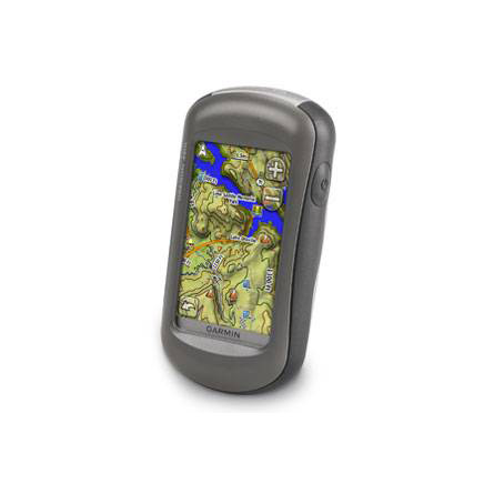
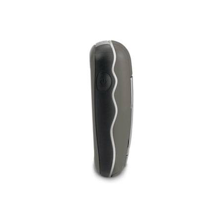
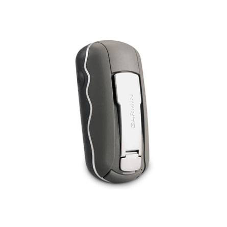
GARMIN Oregon 450t


AC Charger


Speed/Cadence bike sensor (GSC 10)
Heart rate monitor

Premium Heart rate monitor Soft Strap

Replacement Soft Strap for Heart Rate Monitor

Tempe Wireless Temperature Sensor


Replacement Soft Strap for HRM3 Heart Rate Monitor

HRM-Pro Heart Rate Monitor with Bluetooth and Running Dynamics

HRM-Pro Plus Heart Rate Monitor


Cup Holder Universal Mount RAM-A-CAN II with 6 in Flex Arm


Chirp Wireless geocaching beacon

BirdsEye Satellite Imagery Retail Card
Virb X
Virb Xe
NOH Virb XE
VIRB XE Cycling Bundle
VIRB XE Auto Racing Bundle
VIRB XE Aviation Bundle
VIRB Camera
VIRB Elite Camera Dark
VIRB Elite Camera
BirdsEye Satellite Imagery US and Canada
Suggested Maps and Software:
 | Inland Lakes |
 | BlueChart g2, g3 on micro SD card with adapter |
 | Garmin Street Maps and City Navigation |
 | Garmin Topographic Maps |
 | Garmin Extras |
Contents of the package
Features
Tap the touchscreen then hit the trail with Oregon 450t. This next-generation handheld features a rugged, touchscreen along with preloaded topographic maps, 3-D map views, a high-sensitivity receiver, barometric altimeter, electronic compass, microSD card slot, picture viewer and more. Even exchange tracks, waypoints, routes and geocaches wirelessly between similar units.
Touch and Go
Oregon 450t leads the way with a tough, 3-inch diagonal, sunlight-readable, color, touchscreen display that offers crystal clear enhanced colors and high-resolution images. Its easy-to-use interface means youll spend more time enjoying the outdoors and less time searching for information. With user-selectable dashboards, you can customize the appearance of your display. Both durable and waterproof, Oregon 450t is built to withstand the elements. Bumps, dust, dirt, humidity and water are no match for this rugged navigator.
Explore Backcountry in 3-D
Oregon's preloaded U.S. topographic maps, 3-D map view and a built-in worldwide basemap with shaded relief give you all the tools for serious climbing or hiking. Map detail includes national, state and local parks and forests, along with terrain contours, elevation information, trails, rivers, lakes and points of interest. Just in case youre wondering how steep that hill really is, Oregons 3-D map view helps you visualize your surroundings giving you a better perspective of the elevation.
Share Wirelessly
With Oregon 450t you can share your waypoints, tracks, routes and geocaches wirelessly other compatible Oregon, Colorado and Dakota users. Now you can send your favorite hike to your friend to enjoy or the location of a cache to find. Sharing data is easy. Just touch send to transfer your information to similar units.
Find Fun
Oregon 450t supports Geocaching.com GPX files for downloading geocaches and details straight to your unit. By going paperless, you're not only helping the environment but also improving efficiency. Oregon stores and displays key information, including location, terrain, difficulty, hints and descriptions, which means no more manually entering coordinates and paper print outs! Simply upload the GPX file to your unit and start hunting for caches. Show off photos of your excursions with Oregons picture viewer. Slim and lightweight, Oregon is the perfect companion for all your outdoor pursuits.
Get Your Bearings
Oregon 450t has a built-in 3-axis tilt-compensated electronic compass, which shows your heading even when youre standing still, without holding it level. Its barometric altimeter tracks changes in pressure to pinpoint your precise altitude, and you can even use it to plot barometric pressure over time, which can help you keep an eye on changing weather conditions. See changes in your elevation ahead of you and where you've been with enhanced track navigation. With its high-sensitivity, WAAS-enabled GPS receiver and HotFix satellite prediction, Oregon 450t locates your position quickly and precisely and maintains its GPS location even in heavy cover and deep canyons.
Add Maps
Conveniently plug in optional preloaded microSD cards for all your outdoor activities on land or water (see the Maps tab for compatible maps). Just insert a MapSource® card with detailed street maps, and Oregon provides turn-by-turn directions to your destination. Access whitewater runs or explore equestrian trails by purchasing US Trailmaps for Whitewater and Equestrian. Or, you can add regional, detailed trail and lake information with our TOPO U.S. 24K maps. With BlueChart® g2, youll get everything you need for a great day on the water including depth contours, navaids and harbors. The card slot is located inside the waterproof battery compartment, so you don't have to worry about getting it wet.
You've been busy exploring and now you want to store and analyze your activities. With a simple connection to your computer and to the Internet, you can get a detailed analysis of your activities and send tracks to your outdoor device using Garmin Connect. This one-stop site offers an activity table and allows you to view your activities on a map using Google Earth. Explore other routes uploaded by millions of Garmin Connect users and share your experiences on Twitter® and Facebook®. Getting started is easy, so get out there, explore, and share.


Specifications
Installed languages: English,
Spanish, French, Deutsch, Italiano, Portugues, Cesky, Dansk,
Nederlands, Norsk, Suomi, Hrvatski, Magyar, Polski, Russian, Svenska,
Turkse, Latvian, Slovak, Slovenian, Greek, Arabic, Farsi, Bulgarian.
More languages may be available through Garmin web updater.
Physical & Performance:
Unit dimensions, WxHxD: 2.3" x 4.5" x 1.4" (5.8 x 11.4 x 3.5 cm)
Display size, WxH: 1.53"W x 2.55"H (3.8 x 6.3 cm); 3" diag (7.6 cm)
Display resolution, WxH: 240 x 400 pixels
Display type: Transflective color TFT touchscreen
Weight: 6.8 oz (192.7 g) with batteries
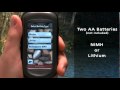
Battery: 2 AA batteries (not included); NiMH or Lithium recommended
Battery life: 16 hours
Waterproof: yes (IPX7)
Floats: no
High-sensitivity receiver: yes
Interface: high-speed USB and NMEA 0183 compatible
RoHS version available: yes
Maps & Memory:
Basemap: yes
Preloaded street maps: yes (topographic)
Ability to add maps: yes
Built-in memory: 850 MB
Accepts data cards: microSD card (not included)
Waypoints/favorites/locations: 2000
Routes: 200
Track log: 10,000 points, 200 saved tracks
Features:
Automatic routing (turn by turn routing on roads): yes (with optional mapping for detailed roads)
Electronic compass: yes (tilt-compensated, 3-axis)
Touchscreen: yes
Barometric altimeter: yes
Camera: no
Geocaching-friendly: yes (paperless)
Custom maps compatible: yes
Outdoor GPS games: yes (Wherigo only)
Hunt/fish calendar: yes
Sun and moon information: yes
Tide tables: yes
Area calculation: yes
Custom POIs (ability to add additional points of interest): yes
Unit-to-unit transfer (shares data wirelessly with similar units): yes
Picture viewer: yes
Item number: 010-00697-41
UPC: 753759100544
Package weight: 1 lb
 | Video by GPS4US |
 | Video by GPS4US |
 | Video by Garmin |
 | Video by Garmin |
 | Video by Garmin |
 | Video by Garmin |
 | Video by Garmin |
 | Video by Garmin |
View latest videos by GPS4US
Visit GPS4US
 Channel.
Following reviews were written by actual customers.
Every GPS4US customer has a chance to live a feedback after receiving a product.
 by Jeff R, , 12/9/2013
DOES EXACTLY WHAT I NEEDED.
by Dan H, , 1/23/2013WORKS VERY WELL, EASY TO HANDLE,LONG BATTERY LIFE, LITE WEIGHT, WOULD RECOMEND TO OTHERS.
by GRAHAM C, , 1/15/2013excellent
by Eric E, , 12/29/2012Fast shipping. Exactly what I expected. Thanks.
Other Products in the Series:
| GARMIN Oregon 200 | Add to comparison |
| GARMIN Oregon 200 NOH | |
| GARMIN Oregon 300 NOH | |
| GARMIN Oregon 300 | Add to comparison |
| GARMIN Oregon 400c | Add to comparison |
| GARMIN Oregon 400c NOH | |
| GARMIN Oregon 400i NOH | |
| GARMIN Oregon 400i | Add to comparison |
| GARMIN Oregon 400t | Add to comparison |
| GARMIN Oregon 400t NOH | |
| GARMIN Oregon 450 | Add to comparison |
| GARMIN Oregon 450 NOH | |
| GARMIN Oregon 450t NOH | |
| GARMIN Oregon 550 NOH | |
| GARMIN Oregon 550 | Add to comparison |
| GARMIN Oregon 550t | Add to comparison |
| GARMIN Oregon 550t NOH | |
| GARMIN Oregon 600 | Add to comparison |
| GARMIN Oregon 600 NOH | |
| GARMIN Oregon 600t NOH | Add to comparison |
| GARMIN Oregon 600t | Add to comparison |
| GARMIN Oregon 650 | Add to comparison |
| GARMIN Oregon 650t | Add to comparison |
| GARMIN Oregon 700 NOH | Add to comparison |
| GARMIN Oregon 700 | Add to comparison |
| GARMIN Oregon 750 | Add to comparison |
| GARMIN Oregon 750t | Add to comparison |