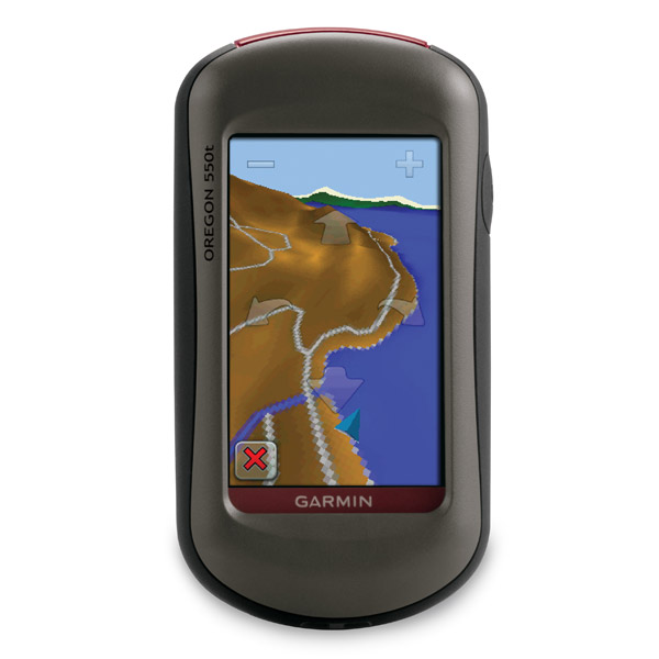
GARMIN Oregon 550t


This item is brand new
$294.95
This item ships within 1 day


AC Charger


Speed/Cadence bike sensor (GSC 10)
Heart rate monitor

Premium Heart rate monitor Soft Strap

Replacement Soft Strap for Heart Rate Monitor

Tempe Wireless Temperature Sensor


Replacement Soft Strap for HRM3 Heart Rate Monitor

HRM-Pro Heart Rate Monitor with Bluetooth and Running Dynamics

HRM-Pro Plus Heart Rate Monitor


Cup Holder Universal Mount RAM-A-CAN II with 6 in Flex Arm


Chirp Wireless geocaching beacon

BirdsEye Satellite Imagery Retail Card
Virb X
Virb Xe
NOH Virb XE
VIRB XE Cycling Bundle
VIRB XE Auto Racing Bundle
VIRB XE Aviation Bundle
VIRB Camera
VIRB Elite Camera Dark
VIRB Elite Camera
BirdsEye Satellite Imagery US and Canada
Suggested Maps and Software:
 | Inland Lakes |
 | BlueChart g2, g3 on micro SD card with adapter |
 | Garmin Street Maps and City Navigation |
 | Garmin Topographic Maps |
 | Garmin Extras |
Contents of the package
Features
If youre looking for a GPS that combines outdoor touchscreen navigation with a digital camera, youve found it in the Oregon 550t. You can also add preloaded US topo maps. It also comes with a high-sensitivity GPS, barometric altimeter, 3-axis electronic compass and a microSD card slot.Snapshots
The Oregon 550ts digital camera will become your best friend. It boasts a 3.2 megapixel autofocus digital camera with 4x digital automatic zoom. You can geotag each photo with its location, which means you can always navigate back to that spot. Take and view photos in landscape or portrait mode, and store them all with 850 megabytes of internal memory. If you need even more storage, just insert a micro SD card. Plus, you can view pictures from other microSD devices with Oregons picture viewer.
See everything
Oregon 550t will show you every detail with its 3-inch diagonal sunlight-readable color touchscreen and simple menu. Plus, a user-friendly interface means youll spend more time appreciating nature and less time with your head buried in the sand. And, of course, the waterproof Oregon 550t can withstand Mother Natures harshest elements, including water, dust, dirt and humidity.
Become an explorer
Your Oregon 550t is preloaded with built-in topographic data for the entire continental US. And, a worldwide basemap with shaded relief gives you all the navigational tools you need for climbing and hiking. The map details national, state and local parks and forests and shows you terrain contours, elevation information, trails, rivers, lakes and points of interest.
Know where youre heading
With a built-in 3-axis tilt-compensated electronic compass, your Oregon 550t shows your heading even when youre standing still or not holding it level. If you want to know your altitude, the barometric altimeter tracks pressure changes to show you how high youre standing. You can even use it to plot barometric pressure, which helps you anticipate changing weather conditions. Plus, the high-sensitivity WAAS-enabled GPS receiver and HotFix satellite prediction shows your location quickly and accurately, no matter where you are.
A new level of geocaching
Oregon 550t gives you paperless geocaching. You can download information form Geocaching.com for up to 5,000 caches. Youll see important details like terrain, difficulty, hints and descriptions. Plus, you no longer have to manually enter coordinates.
Go social
Oregon 550t allows you to share your waypoints, tracks, geocaches and routes wirelessly with other compatible Oregon and Colorado users. All you have to do is press send to transfer your information.


Specifications
Installed languages: English,
Spanish, French, Deutsch, Italiano, Portugues, Cesky, Dansk,
Nederlands, Norsk, Suomi, Hrvatski, Magyar, Polski, Russian, Svenska,
Turkse, Latvian, Slovak, Slovenian, Greek, Arabic, Farsi, Bulgarian.
More languages may be available through Garmin web updater.
Physical & Performance:
Unit dimensions, WxHxD: 2.3" x 4.5" x 1.4" (5.8 x 11.4 x 3.5 cm)
Display size, WxH: 1.53"W x 2.55"H (3.8 x 6.3 cm); 3" diag (7.6 cm)
Display resolution, WxH: 240 x 400 pixels
Display type: Transflective color TFT touchscreen
Weight: 6.8 oz (192.7 g) with batteries
Battery: 2 AA NiMH batteries included
Battery life: 16 hours
Waterproof: yes (IPX7)
Floats: no
High-sensitivity receiver: yes
Interface: high-speed USB and NMEA 0183 compatible
RoHS version available: yes
Maps & Memory:
Basemap: yes
Preloaded maps: yes (topographic)
Ability to add maps: yes
Built-in memory: 850 MB
Accepts data cards: microSD card (not included)
Waypoints/favorites/locations: 2000
Routes: 200
Track log: 10,000 points, 200 saved tracks
Features:
Automatic routing (turn by turn routing on roads): yes (with optional mapping for detailed roads)
Electronic compass: yes (tilt-compensated, 3-axis)
Touchscreen: yes
Barometric altimeter: yes
Geocaching-friendly: yes (paperless)
Outdoor GPS games: yes (Wherigo only)
Hunt/fish calendar: yes
Sun and moon information: yes
Tide tables: yes
Area calculation: yes
Custom POIs (ability to add additional points of interest): yes
Unit-to-unit transfer (shares data wirelessly with similar units): yes
Picture viewer: yes
Additional: camera: yes (3.2 megapixel with autofocus; 4x digital zoom)
Item number: 010-00697-11
UPC: 753759084363
Package weight: 2 lb
 | Video by GPS4US |
 | Video by GPS4US |
 | Video by GARMIN |
 | Video by GARMIN |
 | Video by Garmin |
 | Video by Garmin |
 | Video by Garmin |
 | Video by Garmin |
 | Video by Garmin |
 | Video by Garmin |
 | Video by Garmin |
View latest videos by GPS4US
Visit GPS4US
 Channel.
Other Products in the Series:
| GARMIN Oregon 200 | Add to comparison |
| GARMIN Oregon 200 NOH | |
| GARMIN Oregon 300 NOH | |
| GARMIN Oregon 300 | Add to comparison |
| GARMIN Oregon 400c | Add to comparison |
| GARMIN Oregon 400c NOH | |
| GARMIN Oregon 400i NOH | |
| GARMIN Oregon 400i | Add to comparison |
| GARMIN Oregon 400t | Add to comparison |
| GARMIN Oregon 400t NOH | |
| GARMIN Oregon 450 | Add to comparison |
| GARMIN Oregon 450 NOH | |
| GARMIN Oregon 450t NOH | |
| GARMIN Oregon 450t | Add to comparison |
| GARMIN Oregon 550 NOH | |
| GARMIN Oregon 550 | Add to comparison |
| GARMIN Oregon 550t NOH | |
| GARMIN Oregon 600 | Add to comparison |
| GARMIN Oregon 600 NOH | |
| GARMIN Oregon 600t NOH | Add to comparison |
| GARMIN Oregon 600t | Add to comparison |
| GARMIN Oregon 650 | Add to comparison |
| GARMIN Oregon 650t | Add to comparison |
| GARMIN Oregon 700 NOH | Add to comparison |
| GARMIN Oregon 700 | Add to comparison |
| GARMIN Oregon 750 | Add to comparison |
| GARMIN Oregon 750t | Add to comparison |