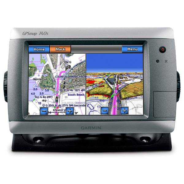
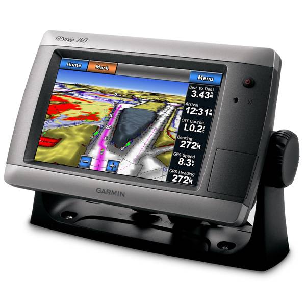
GARMIN GPSMAP 740s


GA 30 GPS antenna (GA 29 replacement)
GPS 17x NMEA 2000 GPS Receiver

GXM 52 - SiriusXM Marine Receiver
GDL 40 Weather Receiver
GXM 51 - Weather and Audio XM Receiver
GHP 10 Marine Autopilot System with GHC 20
GHP 10 Marine Autopilot System with GHC 10

GHP 10V Marine Autopilot System with GHC 10
GHP 10V Marine Autopilot System with GHC 20

GHP 12 Sailboat Autopilot System with GHC 10

GHP 20 Marine Autopilot System for Steer-by-Wire with GHC 10

GHP 20 Marine Autopilot System for Viking with GHC 10
GHP 20 Marine Autopilot System for Yamaha Helm Master with GHC 10
GHP 20 Marine Autopilot System with SmartPump and GHC 10

GHP Reactor Hydraulic Autopilot Corepack

GHP Reactor Mechanical Retrofit Solenoid Corepack

GHP Reactor Hydraulic Corepack with SmartPump

GHP Reactor Steer-by-wire Standard Corepack

GHP Reactor Steer-by-wire Corepack for Yamaha Helm Master

GHP Reactor Steer-by-wire Corepack for Viking VIPER

GHP Reactor Steer-by-wire Corepack for Volvo-Penta

GHP Compact Reactor Hydraulic Autopilot Starter Pack


20 ft. Extension cable for transducers, with ID 6-pin

10 ft. Extension cable for transducers, ID


Ais 300
Ais 600
VHF 300 Black
VHF 300 AIS Black
VHF 100 Black
VHF 100i Black
VHF 100 Silver Grey
VHF 100i International
Vhf 110
VHF 200 Black
VHF 200i Black
VHF 200 Silver Gray
VHF 200i International
VHF 210 AIS Marine Radio
VHF 300 Silver Gray
VHF 300i International
VHF 300i Black
VHF 300i AIS Black
VHF 300 AIS Silver Gray
VHF 300i AIS International

BCN weather cap


SPOD sail pod uncut small MFD display


NMEA 2000 Transducer Adapter Kit
GMR 18 HD Radar
GMR 18 xHD Radar
GMR 24 xHD Radar

GMR 604 xHD Open Array and Pedestal

GMR 606 xHD Open Array and Pedestal

GMR 1204 xHD Open Array and Pedestal

GMR 1206 xHD Open Array and Pedestal

GMR 404/406 Radar Pedestal
GMR 404 Open Array Radar
GMR 406 Open Array Radar
GMR 18 Radar

GMR 24 Radar

GMR 18 HD Plus Radar
GMR 24 HD Radar
GMR 404 xHD Open Array Radar and Pedestal
GMR 406 xHD Open Array Radar and Pedestal

GMR 424 xHD2 Open Array Radar and Pedestal

GMR 624 xHD2 Open Array Radar and Pedestal

GMR 626 xHD2 Open Array Radar and Pedestal

GMR 1224 xHD2 Open Array Radar and Pedestal

GMR 1226 xHD2 Open Array Radar and Pedestal

GBT 10 Bennett Trim Tab Adapter


Speed Sensor


GWind, GMI 20, DST800 Bundle


GWind, GMI 20, GNX 20, DST800 Bundle

GWind, GMI 20, DST800, GNX 20 Wireless Bundle

9-axis Heading Sensor
Gmi 10


GWS 10 Wind Sensor with GMI 20 Bundle

GWS 10 Wind Sensor with GMI 20 and DST800 Bundle

GWS 10 Wind Sensor with GMI 10 and Smart Triducer Bundle
GWS 10 Wind Sensor
GWS 10 Wind Sensor with GMI 10 Bundle

GWind, GMI 20, DST800 Wireless Bundle


P79-6G 200/50KHz 12/45deg plastic adjustable Transducer

M260-6G 1kW 200/50KHz Transducer In hull 6 pin f GSD22

M260-6BR 1kW 200/50KHz 6/19deg mounting tank transducer

B164 1kW 20 tilt 50/200 kHz bronze Transducer 6 pin

P319-6G Nylon 0-8 tilt 50/200 kHz Plastic Transducer

B117 0-8 tilt 50/200 kHz Bronze Transducer 6 pin

B60-12-6g 12 Tilt 50/200 kHz Transducer

B60-20-6g 20 Tilt 50/200 kHz Transducer

B744VL-6G Long STEM DTS 50 200 khz 600 w Bronze Thru Hull Transducer

B744V-6G DTS 50 200 khz 600 w Bronze Thru Hull Transducer

B164 1kW 12 tilt 200/50kHz Bronze Transducer 6pin

B22 12 tilt 200KHZ Bronze Transducer

B258-6g 1kW 50/200 kHz thru-hull 6 pin transducer

B260-6BR 1KW 200/50KHz 6/19deg bronze Transducer

B260-6BR DT Cone 19/6 1kW 200/50KHz Bronze 6pin Transducer

B45-DT-6G Thru-Hull 50/200 kHz Bronz Narrow Stem 6pin Transducer


M260-8G 1kW 200/50kHz In-Hull Plastic Transducer


R599LH 2-3kW CHIRP Transducer


B164 1kW 0 tilt 200/50kHz Bronze Transducer 8-pin
B45-DT-8G Thru-Hull 50/200 kHz Bronz Narrow Stem 8pin Transducer

CM599 LH 2-3kW CHIRP Transducer


R509LM DT 28-130 kHz 2-3kW CHIRP Epoxy Thru-Hull Transducer

SS164 0 deg tilt 1kW Transducer 8pin

SS164 12 deg tilt 1kW Transducer 8 pin

SS164 20 deg tilt 1kW Transducer 8 pin


Airmar Smart Triducer, Plastic Thru, NMEA 2000

Access, Smart Transducer, P39 Transom, Temp, NMEA 2000


DT800 12 tilt NMEA2000 Smart Transducer Plastic


Suggested Maps and Software:
 | Inland Lakes |
 | BlueChart g2, g3 Vision |
 | BlueChart g2, g3 on micro SD card with adapter |
 | Garmin Extras |
 | LakeVu HD |
Contents of the package
- GPSMAP 740s
- Top and bottom snap covers
- Bail mount with built-in cable management
- Knobs
- Flush mount gasket and hardware
- Threaded power/data/sonar cable
- Protective cover
- Documentation
Features
Bring a new level of functionality to your boat with the GPSMAP 740s stand-alonetouchscreen chartplotter. Youre going to marvel at the vivid 7-inch display that
puts all the information you need at the ready. Your GPSMAP 740s comes preloaded with
US coastal maps. Plus, your GPSMAP 740s accepts radar input and gives you full NMEA
2000 connectivity so you can easily add extra sensors.
Around the coasts
Your GPSMAP 740s is preloaded with maps for all US coastal areas, including Alaska,
Hawaii and Bermuda. It features a high-sensitivity GPS receiver, giving you quick and
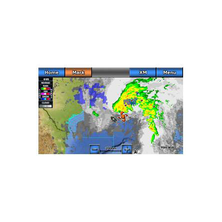
accurate satellite tracking and acquisition times. And yes, theres more. The GPSMAP
740s can receive graphical weather data for all of North America with the optional
GXM 51 satellite receiver/antenna.
A touching experience
With the intuitive touchscreen interface, your GPSMAP 740s makes every operation
easy. If its too bright, use the dimmer to increase readability. And, the waterproof
wide-screen display is perfect for any situation.
On the radar
The GPSMAP 740s features a built-in radar port, which you can link it with Garmins
awesome and affordable line of GMR marine radar systems. Youll love plug-and-play
installation, and Garmins trademark power, range and high definition targeting.
A powerful sonar
Your GPSMAP 720s comes standard with a 1kW-capable sonar transceiver. When you use it
with the 1kW transducer¹, the powerful sonar reaches down to 2,000 feet to help you
define fish targets and underwater structures.
Customize your features
The optional BlueChart g2 Vision card gives you total control of your chartplotters
features.
3D Mariners and Fish Eye view give you a 3D perspective of map information above
and below the surface.
High-resolution satellite images and aerial photographs help you familiarize
yourself in new areas.
Auto Guidance technology searches through all relevant charts to create a route
that avoids
obstacles, shallow water, buoys and other obstructions.


Specifications
Physical & Performance:
Unit dimensions, WxHxD: 8.8" x 5.6" x 3.1" (22.4 x 14.2 x 7.9 cm)
Display size, WxH: 6.0" x 3.6", 7.0" diagonal (15.2 x 9.1 cm, 17.8 cm diagonal)
Display resolution, WxH: 800 x 480 pixels
Display type: WVGA display
Weight: 2.48 lb (1.1 kg)
Battery: none
Battery life: none
Waterproof: yes (IPX7)
High-sensitivity receiver: yes
Antenna: internal
NMEA input/output: NMEA 0183 compatible and NMEA 2000® certified
Maps & Memory:
Basemap: yes
Preloaded maps: yes (coastal maps)
Ability to add maps: yes
Built-in memory: none (cannot load maps to internal memory)
Accepts data cards: SD card slot
Waypoints/favorites/locations: 3,000
Routes: 100
Track log: 20,000 points; 50 saved tracks
Features:
Garmin radar compatible: yes
Garmin sonar compatible: yes (included with sounder version)
Garmin Marine Network compatible: no
Touchscreen: yes
Supports AIS (tracks target ships' position): yes
Supports DSC (displays position data from DSC capable VHF radio): yes
Audible alarms: yes
Tide tables: yes
Hunt/fish calendar: no
Sun and moon information: yes
3-D map view: yes (with optional BlueChart g2 Vision card)
Auto Guidance: yes (with optional BlueChart g2 Vision card)
XM WX Weather & Radio for U.S. & Canada compatible: yes
Automatic routing (turn by turn routing on roads): no
Voice prompts (e.g. "Turn right in 500 ft."): no
Speaks street names (e.g. "Turn right ON ELM STREET in 500 ft."): no
Headphone jack/audio line-out: no
Audio/video input/output: no
Portable: no
Automotive/motorcycle-friendly: no
Item number: 010-00835-03
UPC: 753759099916
Package weight: 7 lb
Following reviews were written by actual customers.
Every GPS4US customer has a chance to live a feedback after receiving a product.
 by Daniel B, , 1/11/2016
Very nice GPS, just what I needed. Work as it should.
Other Products in the Series: