GARMIN Oregon 600


AC Charger


Speed/Cadence bike sensor (GSC 10)
Heart rate monitor

Premium Heart rate monitor Soft Strap

Replacement Soft Strap for Heart Rate Monitor

Tempe Wireless Temperature Sensor


Replacement Soft Strap for HRM3 Heart Rate Monitor

HRM-Pro Heart Rate Monitor with Bluetooth and Running Dynamics

HRM-Pro Plus Heart Rate Monitor


Cup Holder Universal Mount RAM-A-CAN II with 6 in Flex Arm


Chirp Wireless geocaching beacon

BirdsEye Satellite Imagery Retail Card
Virb X
Virb Xe
NOH Virb XE
VIRB XE Cycling Bundle
VIRB XE Auto Racing Bundle
VIRB XE Aviation Bundle
VIRB Ultra 30
VIRB Camera
VIRB Elite Camera Dark
VIRB Elite Camera
BirdsEye Satellite Imagery US and Canada
Suggested Maps and Software:
 | Inland Lakes |
 | BlueChart g2, g3 on micro SD card with adapter |
 | Garmin Street Maps and City Navigation |
 | Garmin Topographic Maps |
 | Garmin Extras |
 | LakeVu HD |
Contents of the package
- Oregon 600
- Worldwide basemap
- USB/charging cable
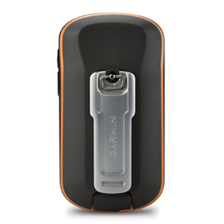
- Carabiner clip
- Documentation
Features
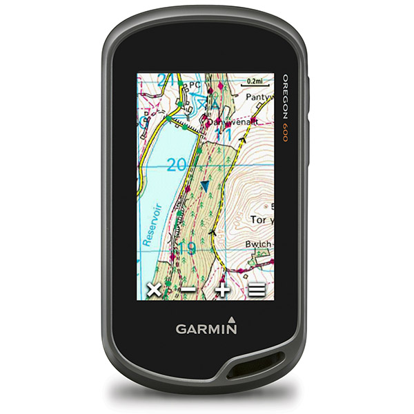
Are you ready to enter into a new world of Garmin GPS mapping and positioning? Then pick up the Oregon 600 and prepare to be blown away.The Oregon 600 gives you high-sensitivity GPS and GLONASS satellite tracking, comes preloaded with worldwide basemap with shaded relief, and features a faster processor that allows you to interact with maps youve previously only looked at. The multi-touch screen lets you rotate and zoom in and out, and works even with gloves on. Youll notice that your screen is just as bright in the daylight sun as in the shade. Thats because of the Oregon 600s reflective display technology. And you can document every point of interest and track back to it with customizable buttons for 1-touch waypoint marking.
Made for the outdoors, and the outdoorsman
The Oregon 600 helps you get in touch with nature. Its sunlight-readable touchscreen is strengthened for impact resistance. And it is designed to fight back against Mother Nature, no matter the elements.
Twice the power
The Oregon 600 gives you a state-of-the-art dual battery system. You can use traditional AA batteries or the optional rechargeable NiMH pack (sold separately). Your NiMH pack charges when your Oregon 600 is connected to an external power source.
Know where you are
Oregon 600 gives you a 3-axis tilt-compensated electronic compass with accelerometer tilt compensation, which shows your heading even when you arent moving or holding it level. Garmin also included a barometric altimeter, tracking pressure changes to pinpoint your precise altitude. Plus, use your Oregon 600 to plot barometric pressure over time to anticipate the changing weather. Even in deep canyons or heavy cover, the Oregon 600 uses its high-sensitivity, WAAS- and GLONASS-enabled GPS receiver and HotFix satellite prediction to find your position quickly and precisely.
Go social
Oregon 600 allows you to share your waypoints, tracks, geocaches and routes up to 50 times faster with other compatible Garmin handheld receivers. You can also send large files to Garmin Adventures and Custom Maps. All you have to do is press send to transfer your information.
Add your own maps
Youll have no problem adding maps to your Oregon 600. You can load TOPO US 24K maps or Trailhead Series TOPO maps and explore famous treks. You can also add BlueChart g2 preloaded cards for your day on the water, or City Navigator map data for turn-by-turn direction in your car. You can also add satellite images with subscription-based BirdsEye Satellite imagery.
A geocachers dream
You want to add geocaches? Well, the Garmin 600 can hold 4 million of them. Yes, thats 4,000,000. You can download every single cache on Opencaching.com or load caches from GSAK and even use any program or website supporting GGZ files*. You can read full descriptions, hints and logs, view cache photos and filter each cache by size, terrain, difficult and type. Plus, you can connect to chirp-enabled caches and record your logs in the field. Really, there is no limit with the Oregon 600.
Take control of your trip
Basecamp software gives you full control of your next trip by letting you view and organize maps, waypoints, routes and tracks. Plus, it comes free and allows you to create Garmin Adventures you can share with friends or fellow explorers. Basecamp brings topographic map data in 2-D or 3-D right to your computer screen, including contour lines and elevation profiles. When you pair it with subscription-based BirdsEye Satellite Imagery, youll also see an unlimited amount of satellite images on your Oregon 600
Specifications
Installed languages: English,
Spanish, French, Deutsch, Italiano, Portugues, Cesky, Dansk,
Nederlands, Norsk, Suomi, Hrvatski, Magyar, Polski, Russian, Svenska,
Turkse, Latvian, Slovak, Slovenian, Greek, Arabic, Farsi, Bulgarian, Romana, Hebrew.
More languages may be available through Garmin web updater.
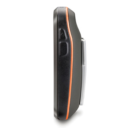
Unit dimensions, WxHxD: 2.4" x 4.5" x 1.3" (6.1 x 11.4 x 3.3 cm)
Display size, WxH: 1.5"W x 2.5"H (3.8 x 6.3 cm); 3" diag (7.6 cm)
Display resolution, WxH: 240 x 400 pixels
Display type: transflective color TFT touchscreen
Weight: 7.4 oz (209.8 g) with batteries
Battery: 2 AA batteries (not included); NiMH or Lithium recommended, rechargeable NiMH pack (optional)
Battery life: 16 hours
Waterproof: yes (IPX7)
Floats: no
High-sensitivity receiver: yes
Interface: high-speed USB and NMEA 0183 compatible
Maps and Memory:
Basemap: yes
Preloaded maps: no
Ability to add maps: yes
Built-in memory: 1.5 GB
Accepts data cards: microSD card (not included)
Waypoints/favorites/locations: 4000
Routes: 200
Track log: 10,000 points, 200 saved tracks
Features and Benefits:
Automatic routing (turn by turn routing on roads): yes (with optional mapping for detailed roads)
Electronic compass: yes (tilt-compensated, 3-axis)
Touchscreen: yes
Barometric altimeter: yes
Camera: no
Geocaching-friendly: yes (paperless)
Custom maps compatible: yes
Photo navigation (navigate to geotagged photos): yes
Hunt/fish calendar: yes
Sun and moon information: yes
Tide tables: Yes (with optional Bluechart)
Area calculation: yes
Custom POIs (ability to add additional points of interest): yes
Unit-to-unit transfer (shares data wirelessly with similar units): yes (plus images and custom maps)
Picture viewer: yes
Garmin Connect compatible (online community where you analyze, categorize and share data): yes
Item number: 010-01066-00
UPC: 753759994822
Package weight: 2 lb
Following reviews were written by actual customers.
Every GPS4US customer has a chance to live a feedback after receiving a product.
 by ABDUHAMIDJON S, , 9/7/2017
Very nice product!!! GPS4US provides professional service!!!!
by Eugene N, , 3/15/2016Excellent deal. Great product I am still learning on. Very pleased.
by Joyce L, , 3/7/2016This was a replacement for a Garmin 62 This was a replacement for a Garmin 62ST,used for Geocaching. The Oregon 600 is by far the most user friendly,eaiser ro read and find geo caches. The touch screen is great and fast. Great Buy.
 by John H, , 2/28/2016
I wish it came with a little more detailed maps, went hiking today and it did not show anything
Other Products in the Series:
| GARMIN Oregon 200 | Add to comparison |
| GARMIN Oregon 200 NOH | |
| GARMIN Oregon 300 NOH | |
| GARMIN Oregon 300 | Add to comparison |
| GARMIN Oregon 400c | Add to comparison |
| GARMIN Oregon 400c NOH | |
| GARMIN Oregon 400i NOH | |
| GARMIN Oregon 400i | Add to comparison |
| GARMIN Oregon 400t | Add to comparison |
| GARMIN Oregon 400t NOH | |
| GARMIN Oregon 450 | Add to comparison |
| GARMIN Oregon 450 NOH | |
| GARMIN Oregon 450t NOH | |
| GARMIN Oregon 450t | Add to comparison |
| GARMIN Oregon 550 NOH | |
| GARMIN Oregon 550 | Add to comparison |
| GARMIN Oregon 550t | Add to comparison |
| GARMIN Oregon 550t NOH | |
| GARMIN Oregon 600 | Add to comparison |
| GARMIN Oregon 600t | Add to comparison |
| GARMIN Oregon 600t NOH | Add to comparison |
| GARMIN Oregon 650 | Add to comparison |
| GARMIN Oregon 650t | Add to comparison |
| GARMIN Oregon 700 NOH | Add to comparison |
| GARMIN Oregon 700 | Add to comparison |
| GARMIN Oregon 750 | Add to comparison |
| GARMIN Oregon 750t | Add to comparison |