GARMIN HuntView Maps Arkansas


This item is brand new
$84.95
Backorder, ships in 3 - 4 weeks


Contents of the package
Features
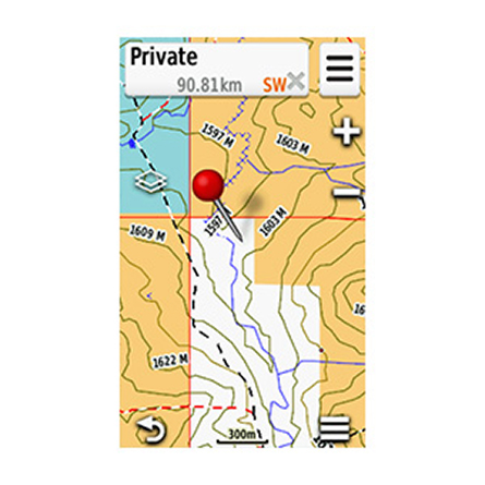
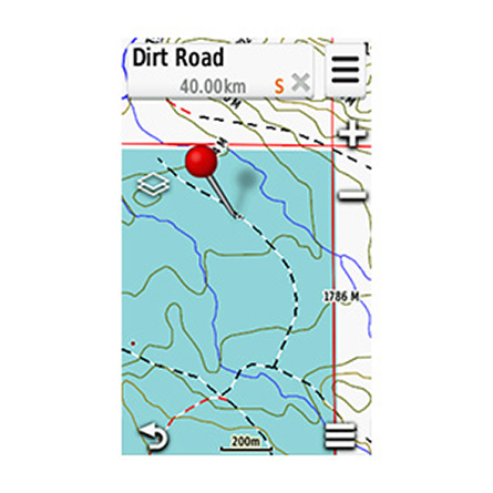
Featuring exclusive BirdsEye Satellite Imagery and 1:24K scale TOPO mapping, these preloaded microSD cards offer a seamless hunting map solution for Garmin handheld GPS devices. Map data is collected from multiple sources, providing full state-by-state coverage with routable road and trail data, landowner names and boundaries for public/private land types and boundaries (BLM, National wildlife refuges, National parks, WPA, WMA), food/fuel locations and more. Included BaseCamp software lets you interface your computer with your handheld device to plan your hunt, transfer waypoints, and even keep a track log so you can return to the best hunting spots or share the adventure online.
- Easy-to-use mapping solution for hunters and outdoorsmen plug-in microSD card eliminates time-consuming downloads
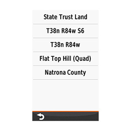
- Identifies landowner names and boundaries for public/private land types and boundaries, using data from multiple sources for superior coverage and detail
- Digital topography equivalent to 1:24,000 scale U.S. Geological Survey maps
- Shows thousands of routable roads and trails with turn-by-turn navigation
- Includes searchable points of interest: parks, summits, geographic place names, camping areas, businesses, and more
- Provides Bureau of Land Management township, range and section information, plus USGS quad location
- Compatible with BaseCamp software for managing data on your GPS and computer, trip planning, playing back routes and tracks, geotagging photos and more
- Full state coverage for other states, sold individually.
Specifications
Features full state hunt view coverage of Arkansas.Item number: 010-12510-51
UPC: 753759166724
Package weight: 0.1 lb
Other Products in the Series:

List of Compatible Units:
Note: Displayed are products sold in gps4us store.
There might be more GPS units compatible with chosen accessory.