GARMIN HuntView Maps Texas West


This item is brand new
$84.95
Backorder, ships in 3 - 4 weeks


Contents of the package
Features
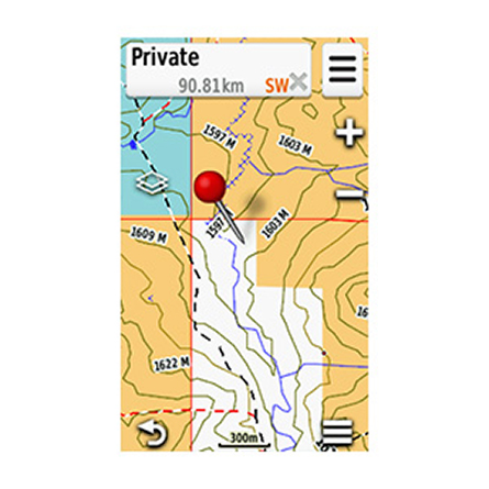
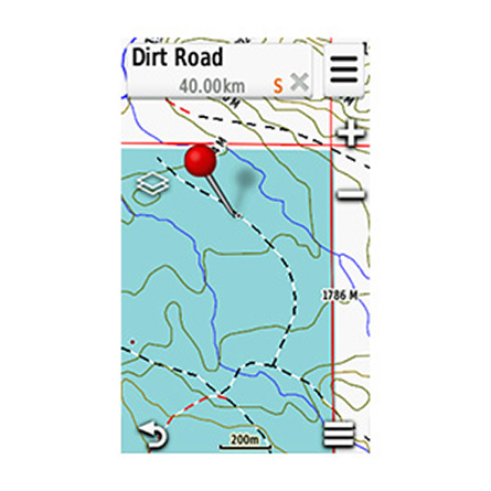
Featuring exclusive BirdsEye Satellite Imagery and 1:24K scale TOPO mapping, these preloaded microSD cards offer a seamless hunting map solution for Garmin handheld GPS devices. Map data is collected from multiple sources, providing full state-by-state coverage with routable road and trail data, landowner names and boundaries for public/private land types and boundaries (BLM, National wildlife refuges, National parks, WPA, WMA), food/fuel locations and more. Included BaseCamp software lets you interface your computer with your handheld device to plan your hunt, transfer waypoints, and even keep a track log so you can return to the best hunting spots or share the adventure online.
- Easy-to-use mapping solution for hunters and outdoorsmen plug-in microSD card eliminates time-consuming downloads
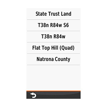
- Identifies landowner names and boundaries for public/private land types and boundaries, using data from multiple sources for superior coverage and detail
- Digital topography equivalent to 1:24,000 scale U.S. Geological Survey maps
- Shows thousands of routable roads and trails with turn-by-turn navigation
- Includes searchable points of interest: parks, summits, geographic place names, camping areas, businesses, and more
- Provides Bureau of Land Management township, range and section information, plus USGS quad location
- Compatible with BaseCamp software for managing data on your GPS and computer, trip planning, playing back routes and tracks, geotagging photos and more
- Full state coverage for other states, sold individually.
Specifications
Features full state hunt view coverage of Texas West part of state.East Texas card includes HuntView maps for entire state of Texas; however, only offers
BirdsEye Satellite Imagery for western part of state
Item number: 010-12522-51
UPC: 753759168940
Package weight: 0.1 lb
Other Products in the Series:

List of Compatible Units:
Note: Displayed are products sold in gps4us store.
There might be more GPS units compatible with chosen accessory.